
The Ely Wildspace
 The eastern edge of Ely harbours valuable habitat for wildlife, including lakes, reed beds, seasonally flooded meadows, woodlands and grasslands. These areas support an impressive array of wildlife and are highly valued by many people who visit the area. Through discussions with Ely residents (at a public meeting and on market stalls), relevant landowners, our members, and ecologicalexperts (Wildlife Trust, Natural England and others) we have identified an area - which we are calling the Ely Wildspace - that needs to be conserved and managed in an integrated way for the combinedbenefit of both wildlife and local people. We believe that protectingthe Wildspace from harmful development is essential for safeguarding Ely's remaining wildlife and securing a vital recreational resource for a growing city.
Ely Wildspace is critical for the survival of wildlife in the area. Some of the species found here are of national conservation importance. In recognition of this Natural England, the government’s advisor on the natural environment in England, has designated most of the Wildspace as a Site of Special Scientific Interest (SSSI), giving it the highest level of protection at a UK level. For more information on the Ely Pits and Meadows SSSI’s and why it was designated please visit the natural England website by clicking here
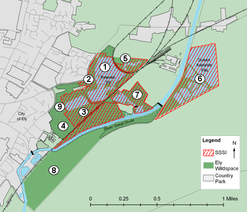
Map of the Ely Wildspace. Click on numbered areas for more information.
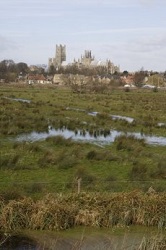
East Cambridgeshire District Council have also recognised that the area is an important recreational resource and are in the process of developing a country park, overlapping with much of the Wildspace. While we support the idea of improving access to some areas, we believe that any development must be done with a light touch and in line with the SSSI designation.
 1. Roswell Pits
The complex of Roswell Pits was excavated to provide clay for the construction and repair of flood banks along the Fenland rivers. Workings in the Pits date back to the 17th century and continued until the late 20th century, although there is evidence that clay and stone were dug long before that time.
The oldest and largest of these pits is the 'Sailing Club', eastern, Pit. As recently as 1913 the clay was dug by hand and taken by wheelbarrow to waiting wooden 'lighters' to be transported to the river banks. At least 100 barges operated during the busiest times. Some idea of the amount of clay taken away can be gained from the fact that the site of the western Pit was previously known as Roswell Hill!
2. Ely Common
 Ely Common extends along Prickwillow Road from Lisle Lane up to Ely Sailing Club. It has been managed and used as a traditional common for many years, and this was officially recognised in 2012 when after a prolonged legal process led by Ely Wildspace the Common was declared a Town Green. This conferred on the Common the legal protection enjoyed by registered commons. The eastern part of the Common (from Kiln Lane to the Sailing Club is also a part of the Ely Pits and Meadows Site of Special Scientific Interest (SSSI) established in 2008, which provides protection against detrimental changes to the ecology of the site. These designations are important for the protection against development of part of the eastern Common which is owned by a commercial organisation. The rest of the Common is owned by local charitable trust the Thomas Parsons' Charity, but is held on a 25 year lease by East Cambridgeshire District Council (ECDC), and forms a part of the Ely Country Park.
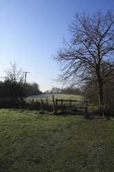
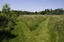
3. Springhead Lane and meadow
 Springhead Lane, also known as 'Lovers Lane', is an ancient path, which supports a wide variety of wildlife and fauna. A popular route for walkers and wildlife watchers, it is the last vestige of what was formerly one of the most important routes into Ely. This led from Turbutsey, (where there was a quay on the old course of the river), to the Cathedral.
4. Pocket Park
 Pocket Park lies between the water treatment plant, the railway Line and Springhead Lane & meadow and is the closest part of Wildspace to the city centre. The area is well used because of the surfaced paths, play equipment, and short grass for games and picnics. The raised area next to the railway line gives good views over the washland and river to Stuntney. The area is also known as the Cresswells or Cresswells Pocket Park because it is situated on what were medieval watercress beds. These were sighted here because of the fresh water from a line of springs provided ideal conditions.
5. Turbutsey and Railway loop land
 This area was part of the land known as Turbutsey, a port/hythe and, via Springhead Lane, one of the most important routes into Ely prior to the diversion of the river in about 1200 A.D. Turbutsey was one of the oldest possessions of the Ely Monastery, belonged to the Sacrist of the Monastery.
It extended from the old Sugar Beet Factory site towards the Sailing Club. The farm at Turbutsey produced much of the food required for the Sacrist's
Department. There was also a chapel and kilns for the manufacture of bricks and tiles. Peat was dug there for use as fuel.
This area was part of the land known as Turbutsey, a port/hythe and, via Springhead Lane, one of the most important routes into Ely prior to the diversion of the river in about 1200 A.D. Turbutsey was one of the oldest possessions of the Ely Monastery, belonged to the Sacrist of the Monastery.
It extended from the old Sugar Beet Factory site towards the Sailing Club. The farm at Turbutsey produced much of the food required for the Sacrist's
Department. There was also a chapel and kilns for the manufacture of bricks and tiles. Peat was dug there for use as fuel.
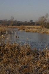
6. Queen Adelaide Pits
 Queen Adelaide Pits lie to the east of the river and Adelaide Way. They are very important for wetland birds including bittern, marsh harrier, bearded tits, hobbies and a variety of wildfowl. The pits are in private ownership but can be viewed from Adelaide Way.
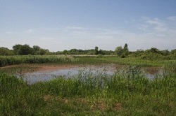
7. Cuckoo Bridge and Reed Beds
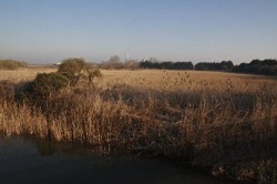 Cuckoo bridge is aptly named, as cuckoos can frequently be heard in this area. It is possible that the number of reed buntings and reed warblers attract them as the nests of these species are often used as a foster 'cradle' by the cuckoo.
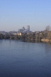
8. River flood meadows
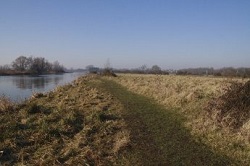 The meadow between the railway and the River Great Ouse has in the past been an important breeding site for lapwings, whose numbers as a breeding species have declined drastically in recent years. Lapwings are vulnerable to disturbance by walkers and dogs, and to protect the site Ely Wildspace volunteers in co-operation with Natural England and the farmer in 2011 replanted and restored the hedge between the meadow and the riverside public footpath. Post and rail fencing was erected to guard the newly planted hedge from grazing cattle. Signs were placed asking the public to stay on the footpath side of the fence and to keep their dogs off the meadow.
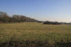
9. Lisle Lane field
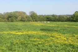 Sitting on the northern outcrop of Kimmeridge Clay, Lisle Lane field has been used for grazing for many years. Species such as water cress and buttercups can be found.